

If you're planning a trip from Queenstown to Milford Sound, did you know that a 280-kilometer drive can easily take five hours despite what your screen says? Finding the best navigation app for driving in new zealand isn't just about finding the shortest route. It's about surviving the signal dead zones of the Southern Alps and managing the reality of our winding, single-lane highways where average speeds often hover around 70 to 80 km/h. Most travelers expect their phone maps to work everywhere, but New Zealand's rugged terrain often has other plans. You likely worry about losing your way in remote areas or getting hit with unexpected road closures that don't show up on a basic GPS.
This 2026 guide will show you how to maintain a reliable connection using a hybrid strategy of real-time data and offline backups. You'll discover which apps provide the most accurate travel times and how to get real-time alerts for road works. We also explain why a modern compact SUV or sedan equipped with smartphone mirroring is your best hardware for staying on track. You'll learn to navigate like a local, ensuring your focus stays on the scenery rather than a searching for signal icon.
Key Takeaways
- Understand why New Zealand’s unique topography creates signal dead zones and how to adjust your travel time estimates for winding rural roads.
- Compare the top contenders to find the best navigation app for driving in new zealand, balancing real-time city traffic data with reliable rural mapping.
- Learn how to use offline maps and pre-cached data to navigate safely through the wilderness without relying on a mobile signal.
- Integrate essential local tools like Gaspy and Waka Kotahi to find the best fuel prices and receive official alerts on road closures.
- Discover why modern vehicle features like Apple CarPlay and Android Auto are vital for a stress-free journey in a compact SUV or sedan.
Why Navigation in New Zealand is a Unique Challenge
Driving through New Zealand is a visual dream but a digital hurdle for those who aren't prepared. Unlike the flat, predictable highway systems found in many other countries, our landscape is defined by its extreme verticality and remote stretches. This creates immediate issues for anyone searching for the best navigation app for driving in new zealand. You aren't just navigating streets; you're navigating a topography that actively works against modern technology.
Geography vs. Technology: The Signal Gap
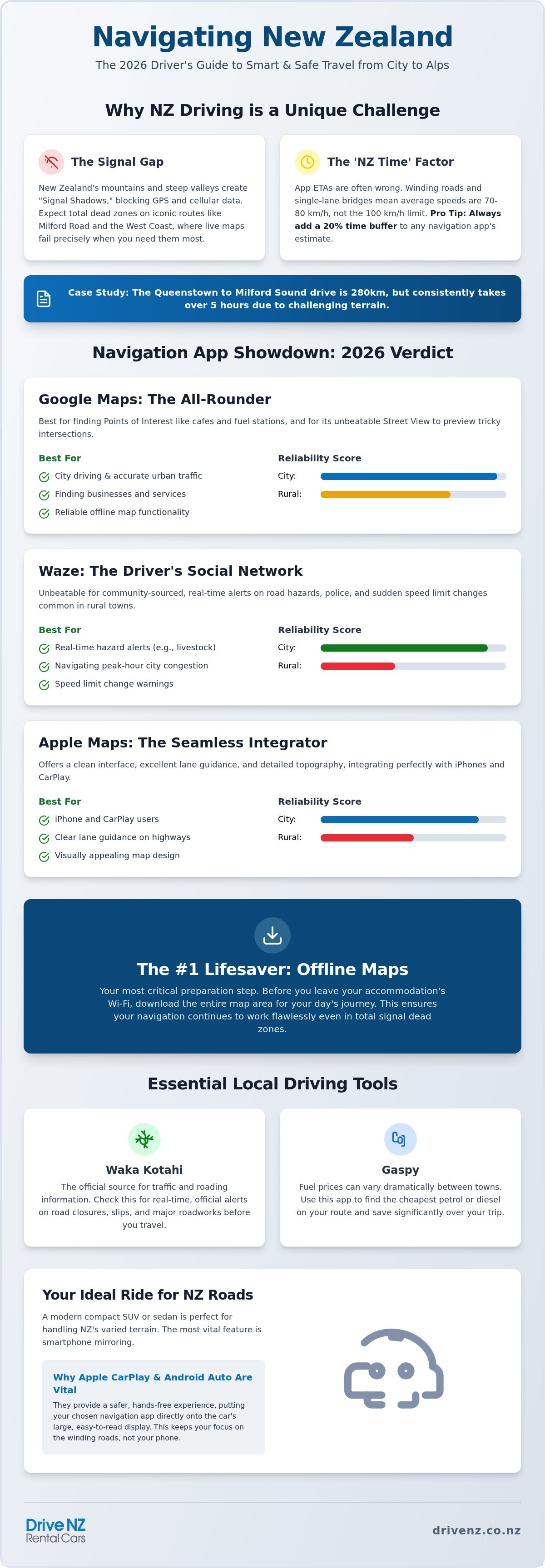
The most significant hurdle for digital mapping is the "Deep Valley" problem. Our steep mountains and dense native bush act as physical barriers for both satellite and cellular signals. In the context of the Southern Alps, a Signal Shadow occurs when the massive scale of the mountains physically blocks the line of sight required for GPS satellites to communicate with your smartphone. When this happens, your position on the map might lag or disappear entirely.
Travelers often encounter total dead zones along the West Coast, the Milford Road, and the Central Plateau. A standard trip in a rental car can easily cross three signal-less zones in a single afternoon. If your chosen app relies solely on a live data connection, your map will stop updating exactly when the roads become most complex. This is why relying on a single live-streamed map is a risk most locals avoid.
The 'NZ Time' Factor on Digital Maps
Digital maps often struggle with what locals call "NZ Time." While a 100km stretch in Europe or the US might take an hour, that same distance on the South Island could easily take two. This discrepancy happens because global algorithms often fail to account for the physical reality of our winding terrain, frequent one-lane bridges, and the sudden transition from sealed highways to gravel roads. Even a comprehensive comparison of navigation apps shows that many platforms are optimized for urban grids rather than mountain passes.
Apps calculate travel times based on speed limits, but those limits are often impossible to reach safely on a tight mountain road. You should always add a 20% buffer to any app-predicted arrival time. This gives you space to handle unexpected rural road closures or wait your turn at a one-lane bridge without the stress of running late. Modern vehicles like an intermediate sedan or a compact SUV provide the perfect platform for these apps via smartphone mirroring, but you still need to understand the local data to stay on schedule.
Google Maps vs. Waze vs. Apple Maps: The 2026 Verdict
Google Maps remains the heavyweight for business discovery. Waze is the king of the commute. Apple Maps has caught up with impressive 2026 topography updates. However, selecting the best navigation app for driving in new zealand depends on where you are. In Auckland or Christchurch, live data is your best friend. In the Southern Alps, that same data becomes a liability when the 5G bars disappear. All three of these giants share a critical flaw: they are heavily reliant on a stable connection to provide real-time updates.
This reliance on connectivity isn't just a challenge for navigation; it's a vital consideration for modern business operations. To mitigate these risks, YourCloud provides managed IT support and cybersecurity services, ensuring that your company's digital infrastructure remains robust and secure regardless of location.
Google Maps: The All-Rounder
Waze: The Driver's Social Network
Waze thrives on its community. It's the superior choice for spotting hazards like fallen trees or livestock on the road, which are common occurrences in rural New Zealand. It's also remarkably good at navigating Auckland's peak-hour congestion by finding clever shortcuts that other apps might miss. One major benefit for visitors is how Waze handles the 'hidden' speed limits in small rural towns. These zones often drop from 100km/h to 50km/h very quickly. Waze provides timely alerts to help you stay within the law and avoid heavy fines.
Apple Maps and the Signal Problem
Apple Maps received significant updates in 2026, including better lane guidance and detailed topography for our mountain passes. It feels modern and integrates perfectly with iPhone-enabled vehicles. But the reality is that once you enter a signal shadow in the Southern Alps, these apps can't update your route if you take a wrong turn. To make the most of these tools, you need a vehicle that supports them effortlessly. Choosing a modern rental car with smartphone mirroring ensures these apps are displayed clearly on your dashboard, keeping your eyes on the road and your focus on the journey.
The Lifesaver: Best Apps for Offline Navigation
Relying on a live data connection in the Southern Alps or the remote West Coast is a recipe for frustration. While Google and Waze are excellent in urban centers, they often fail when you enter the signal shadows we discussed earlier. Finding the best navigation app for driving in new zealand requires a hybrid approach. You need a tool that stays functional when your 5G bars vanish, ensuring you don't miss a crucial turn-off to a scenic lookout or a remote trailhead.
Setting Up Google Maps for Offline Success
Google Maps allows you to download massive geographical areas directly to your phone's internal storage. This is the most reliable way to maintain navigation through the Central Plateau or deep South Island valleys. To set this up, tap your profile picture in the app, select 'Offline maps', and then 'Select Your Own Map'. You can pinch and zoom to highlight specific regions like the entire South Island. A complete offline cache for both the North and South Islands usually requires between 800MB and 1.5GB of available storage on your device. Once downloaded, go into your settings and toggle 'Wi-Fi Only' to ensure the app doesn't try to use expensive international roaming data while you drive.
There are trade-offs to this approach. When you go offline, you lose real-time traffic updates, dynamic arrival times, and automatic rerouting for road accidents. You also won't see live business hours or fuel prices. Your phone's processor works harder when it can't offload calculations to the cloud, meaning offline navigation can drain your battery significantly faster. Always keep your device plugged into your vehicle's USB port to avoid a dead battery in the middle of a remote pass.
Maps.me: The Backcountry Specialist
For travelers who want to venture further off the beaten path, Maps.me is an essential secondary tool. It uses OpenStreetMap data, which is often more detailed than Google for rural New Zealand tracks, hiking trailheads, and obscure scenic lookouts. It's particularly useful for plotting a complex multi-stop route between Christchurch and Queenstown. You can drop bookmarks at every waterfall and photo point without needing a single byte of data. Combining the detailed mapping of Maps.me with a compact SUV rental gives you the confidence to explore gravel roads and remote coastal spots where standard apps might only show a blank screen. This combination of reliable hardware and specialized software ensures you remain in control of your journey, regardless of cellular coverage.
Essential Driving Companions: Fuel, Safety, and Road Conditions
While finding the best navigation app for driving in new zealand solves your routing needs, it's the secondary companion apps that handle your budget and safety. A Kiwi road trip involves more than just following a blue line on a screen. You need to manage high fuel costs, unpredictable weather, and official road statuses that global maps often lag behind on. These specialized tools provide the local context you need to stay safe and on budget.
Gaspy: Beating NZ's High Fuel Prices
Gaspy is a non-negotiable download for any traveler. With gasoline prices averaging around NZ$3.14 per liter in August 2026, fuel costs can quickly become your biggest daily expense. The app relies on community-sourced 'Spy' reports to show you the cheapest prices on your current route. You'll quickly notice a significant price gap between major hubs like Auckland and remote South Island towns where supply chains are longer. Use the app to plan your last fill-up before returning your vehicle to avoid the premium rates often found at stations near the airport.
Waka Kotahi: The Source of Truth
The Waka Kotahi (NZTA) Journey Planner is the only official source of truth for road closures and hazard alerts. It's often the best navigation app for driving in new zealand when conditions get tough, as it's the only platform with real-time data on snow chain requirements for alpine roads. If you're traveling between June and October, this app is vital. Alpine passes can close within minutes due to ice or sudden snowfall. Before you head into the mountains, check our snow chain hire guide to ensure you're prepared for winter safety. Most global apps are slow to reflect these official government closures, so checking Waka Kotahi before you start your engine is a local's secret to avoiding long detours.
Safety also means staying informed about the environment. GeoNet provides essential alerts for seismic activity and extreme weather events, which are a reality of the New Zealand landscape. For the more practical side of the road, CamperMate is invaluable for car users too. It helps you find clean public toilets, rubbish bins, and hidden viewpoints that aren't always marked on standard maps. Having these tools at your fingertips ensures that your focus remains on the scenery rather than the logistics.
Having the right software is vital, but so is having the right hardware. Explore our range of compact SUVs and sedans to find the perfect, tech-ready partner for your New Zealand adventure.
Maximizing Your Drive NZ Rental with Smart Navigation
Choosing the best navigation app for driving in new zealand is only half the battle. To ensure a stress-free journey, you need a vehicle that displays your maps safely and keeps your device powered throughout the day. Modern smartphone mirroring, specifically Apple CarPlay and Android Auto, has transformed the way travelers navigate our roads. Instead of squinting at a small phone screen suction-cupped to a windshield, you can access your pre-cached maps and real-time alerts directly on a high-definition dashboard screen.
Using built-in screens is significantly safer than relying on temporary phone mounts. It allows for voice-activated commands, which are vital when navigating the tight turns and sudden intersections common in the South Island. Whether you choose an intermediate sedan for city efficiency or a compact SUV for better visibility on rural roads, ensuring your vehicle is tech-ready is a priority for a modern traveler. This integration ensures that the signal shadows we discussed earlier don't result in a loss of focus on the road.
Tech-Ready Fleet: Auckland & Christchurch
Our modern fleet is designed to be the perfect hardware for your digital tools. Every vehicle in our compact hatchback and SUV range features smartphone connectivity, allowing for seamless integration of the apps we've discussed. When you pick up your car at our Auckland or Christchurch depots, take a moment to sync your device via the USB port. Because high-drain GPS apps can quickly deplete your phone's battery, we recommend keeping your device plugged in rather than relying on Bluetooth alone.
A pro tip for a smooth return is to set our depot address as your 'Home' or 'Work' location in your navigation app immediately. This ensures that on your final day, you can navigate back to the drop-off point with a single tap, avoiding any last-minute stress or navigation errors during your flight check-in window. It's a small step that provides significant peace of mind at the end of your trip.
Final Safety Check Before You Hit the Road
Before you leave the depot, perform a final digital audit. Set your primary destination while stationary to avoid the temptation of fiddling with your screen while driving. If you've followed our advice on using the best navigation app for driving in new zealand with offline capabilities, verify that your downloads are 100% complete while you still have access to the city's high-speed Wi-Fi. It's much easier to fix a download error in Auckland than it is on the side of a mountain pass with no reception.
- Sync your phone and test the dashboard mirroring.
- Verify all offline map regions are downloaded.
- Input the depot address for an easy return.
- Confirm your device is charging properly.
Ready to start your adventure with a reliable partner? Your journey begins with the right vehicle. Take the first step and book your tech-ready vehicle at Drive NZ Rental Cars today.
Start Your New Zealand Journey with Confidence
Navigating the diverse landscapes of Aotearoa requires more than just a standard smartphone map. Success on our roads comes from a strategic hybrid approach: using real-time data for urban navigation and reliable offline backups for the rugged wilderness. By combining global leaders with local specialized tools like Gaspy and Waka Kotahi, you ensure that you're always informed about fuel prices and official road statuses. This combination truly represents the best navigation app for driving in new zealand, giving you the freedom to explore without the fear of getting lost in a signal shadow.
The right software needs the right hardware to be effective. Drive NZ Rental Cars has been a trusted local operator since 2005, providing modern vehicles that act as the perfect platform for your travel apps. Our fleet is equipped with Apple CarPlay and Android Auto, ensuring your maps are always visible on a clear dashboard screen. With expert local support in Auckland and Christchurch, we help remove the complexity from your trip. Book your tech-ready rental car for your NZ adventure today and experience a seamless journey from start to finish. We can't wait to help you get on the road.
Frequently Asked Questions
Does Google Maps work offline in New Zealand?
Yes, Google Maps works offline if you download your required regions before leaving a Wi-Fi zone. You can save specific areas like the entire South Island directly to your phone's storage. This allows you to view maps and get driving directions without using any cellular data. It's a critical backup for remote areas where signals frequently drop out during long stretches of the drive.
What is the best app for road closures in NZ?
The Waka Kotahi (NZTA) Journey Planner is the only official source for road closures and real-time hazard alerts. It provides the most accurate information on snow chain requirements and emergency detours across the country. we recommend checking this app every morning during winter before you head into alpine passes. It's the only tool that reflects government-mandated closures the moment they happen.
Is there a free navigation app for New Zealand that doesn't use data?
Maps.me is the top choice for a free, data-free experience. It uses OpenStreetMap data and allows you to download the entire country for offline use. It's often considered the best navigation app for driving in new zealand when heading into the backcountry because it includes detailed trailheads and remote scenic lookouts that other global apps often miss or show as blank spaces.
Can I use Waze in New Zealand for speed trap alerts?
You can definitely use Waze in New Zealand for speed trap alerts and hazard reporting. The app has a strong user base in major cities like Auckland, where community members report police locations and speed cameras in real-time. It's an excellent tool for navigating urban traffic and staying aware of sudden speed limit drops in rural villages where enforcement is often quite strict for visitors.
How do I find the cheapest petrol in NZ while driving?
Gaspy is the most effective app for finding the cheapest petrol prices while you're on the road. It uses community-sourced data to provide a live map of fuel costs at nearby stations. Because prices can fluctuate by over 30 cents per liter between competing brands, checking the app before you fill up can lead to significant savings over the course of a two-week road trip.
What happens if I lose GPS signal in the Southern Alps?
If you lose cellular signal, your phone's internal GPS chip will still function, but your map won't update unless it's cached. This is where pre-downloaded offline maps are vital. Your position will still show on the screen, but you won't get new routing instructions or traffic updates until you return to a coverage area. Always ensure your route is started before you enter these dead zones.
Do rental cars in NZ come with built-in GPS?
Most modern rental fleets, including ours, prioritize smartphone mirroring over built-in GPS units. Our compact SUVs and sedans feature Apple CarPlay and Android Auto as standard. This allows you to use your preferred apps on the car's dashboard, providing a more familiar and up-to-date navigation experience than many older factory-installed systems. It also ensures you have access to your saved places and personal settings.
Is Apple Maps or Google Maps more accurate for NZ travel times?
Both apps often underestimate travel times on winding rural roads, though Apple Maps received significant topography updates in 2026. For the best navigation app for driving in new zealand, always add a 20% buffer to any estimated arrival time. This accounts for the reality of one-lane bridges and the slower speeds required on mountain passes. Relying on the app's initial estimate without a buffer often leads to unnecessary stress.


